Property Record
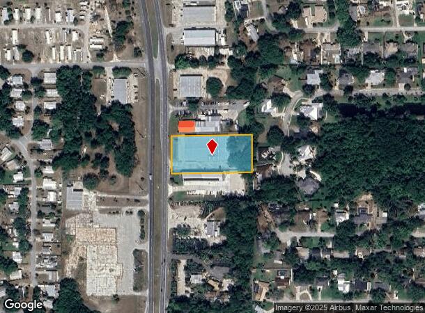
3650 N Highway 1, Cocoa, FL 32926

NEARBY LISTINGS FOR SALE OR LEASE
-
-
View all Cocoa listings for sale on LoopNet.com
Property Detail
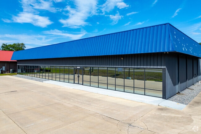
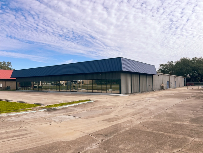
3650 N Highway 1
Palm Bay-Melbourne-Titusville, FL
Acreage
24-36-08-00-00278.0-0000.00
PART OF GOVT LOT 2 E OF US HWY 1 AS DES IN ORB 2748 PG 816
Storebuilding
Brevard
X
Florida
12009C0320H
2
2024
1.70 AC
2025
Brevard County
062112
Orlando
24,800 SF
DEMOGRAPHICS near 3650 N Highway 1
1 mile
3 mile
5 mile
2024 Total Population
1,403
22,668
73,875
2029 Population
1,561
24,765
80,620
Pop Growth 2024-2029
+ 11.26%
+ 9.25%
+ 9.13%
Average Age
49
44
44
2024 Total Households
595
9,510
30,522
HH Growth 2024-2029
+ 11.09%
+ 9.01%
+ 8.90%
Median Household Inc
$79,066
$52,600
$56,177
Avg Household Size
2.40
2.30
2.30
2024 Avg HH Vehicles
2.00
2.00
2.00
Median Home Value
$285,416
$257,768
$261,700
Median Year Built
1980
1983
1981
Nearby Places
Map Layers
Map Styles
 Street
 Aerial
Transit
 Traffic
 Biking
Places
Listings with unknown addresses are not visible on the map
- Restaurants
- Banks
- Shops
- Fitness
- Groceries
PUBLIC TRANSPORTATION
AIRPORT
Melbourne Orlando International
Drive
Walk
Distance
Melbourne Orlando International
43 min
30.6 mi
Freight Ports
Port Canaveral
Drive
Walk
Distance
Port Canaveral
15 min
10.0 mi
SALE & LEASE HISTORY
LISTING DATE
SALE/LEASE

May 15, 2017
For Sale
May 08, 2025
For Lease
Feb 26, 2025
For Sale
Feb 09, 2024
For Lease
Aug 22, 2025
For Sale
Aug 20, 2024
For Sale
Aug 11, 2017
For Sale
Nearby Properties
Address
Land Use
TOTAL SIZE
Lot Size
Zoning
Address
Land Use
TOTAL SIZE
Lot Size
Zoning
825,903 SF
94.80 AC
RU17
Address
Land Use
TOTAL SIZE
Lot Size
Zoning
413,008 SF
127.62 AC
GMLH
Address
Land Use
TOTAL SIZE
Lot Size
Zoning
335,014 SF
185.59 AC
M2
Address
Land Use
TOTAL SIZE
Lot Size
Zoning
307,934 SF
13.66 AC
RU215
Address
Land Use
TOTAL SIZE
Lot Size
Zoning
176,670 SF
13.49 AC
CG
Address
Land Use
TOTAL SIZE
Lot Size
Zoning
264,679 SF
59.90 AC
RU17
Address
Land Use
TOTAL SIZE
Lot Size
Zoning
211,753 SF
25.16 AC
CG
Address
Land Use
TOTAL SIZE
Lot Size
Zoning
96,878 SF
17.47 AC
CN
Address
Land Use
TOTAL SIZE
Lot Size
Zoning
75,552 SF
9.95 AC
PUD
Address
Land Use
TOTAL SIZE
Lot Size
Zoning
96,814 SF
8.89 AC
RU215
Address
Land Use
TOTAL SIZE
Lot Size
Zoning
144,430 SF
14.02 AC
M2
Address
Land Use
TOTAL SIZE
Lot Size
Zoning
95,535 SF
12.69 AC
AU
Address
Land Use
TOTAL SIZE
Lot Size
Zoning
52,398 SF
9.68 AC
M2
Address
Land Use
TOTAL SIZE
Lot Size
Zoning
109,153 SF
20 AC
RU17
Address
Land Use
TOTAL SIZE
Lot Size
Zoning
65,645 SF
107.50 AC
GML
Address
Land Use
TOTAL SIZE
Lot Size
Zoning
59,448 SF
6.46 AC
RU2-15
Address
Land Use
TOTAL SIZE
Lot Size
Zoning
107,340 SF
7.64 AC
CR
Address
Land Use
TOTAL SIZE
Lot Size
Zoning
222,813 SF
20.01 AC
CP
Address
Land Use
TOTAL SIZE
Lot Size
Zoning
126,270 SF
20.99 AC
M2
Address
Land Use
TOTAL SIZE
Lot Size
Zoning
79,371 SF
12.44 AC
RU17
Address
Land Use
TOTAL SIZE
Lot Size
Zoning
92,025 SF
3.08 AC
RU225
Address
Land Use
TOTAL SIZE
Lot Size
Zoning
7,788 SF
200 AC
GML
Address
Land Use
TOTAL SIZE
Lot Size
Zoning
46,975 SF
10.90 AC
INL
Address
Land Use
TOTAL SIZE
Lot Size
Zoning
92,647 SF
7.02 AC
BU-2
Address
Land Use
TOTAL SIZE
Lot Size
Zoning
42,936 SF
27.69 AC
GU
Address
Land Use
TOTAL SIZE
Lot Size
Zoning
27,783 SF
8.91 AC
CN
Address
Land Use
TOTAL SIZE
Lot Size
Zoning
34,296 SF
1.41 AC
RU215
Address
Land Use
TOTAL SIZE
Lot Size
Zoning
15,320 SF
113.85 AC
AU
Address
Land Use
TOTAL SIZE
Lot Size
Zoning
58,962 SF
4.01 AC
BU1
Address
Land Use
TOTAL SIZE
Lot Size
Zoning
38,646 SF
9.23 AC
CN
The World's #1 Commercial Real Estate Marketplace
Connect with us
© 2026 CoStar Group
The information above has been obtained from sources believed reliable. While we do not doubt its accuracy we have not verified it and make no guarantee, warranty or representation about it. It is your responsibility to independently confirm its accuracy and completeness. Any projections, opinions, assumptions, or estimates used are for example only and do not represent the current or future performance of the property. The value of this transaction to you depends on tax and other factors which should be evaluated by your tax, financial, and legal advisors. You and your advisors should conduct a careful, independent investigation of the property to determine to your satisfaction the suitability of the property for your needs.